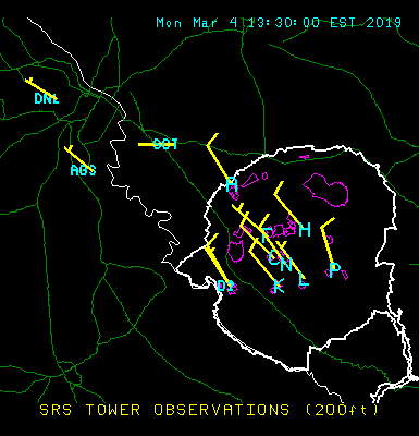
Current Observations
Data values are 15-min averages for period ending 2019-03-04 13:45
** Scroll Table to see rest of data **
| SRS Towers (Measurements at 200 ft above ground) | ||||||
|---|---|---|---|---|---|---|
| Location | Temp. | Humidity | Wind Speed | Wind Dir. | Max Gust | Stability (1) |
| A Area | 46° F | 76 % | 8.1 mph | 328°('NNW) | 16.6 mph | D |
| C Area | 47° F | 73 % | 10.0 mph | 314°('NW) | 15.5 mph | D |
| D Area | 48° F | 68 % | 10.9 mph | 330°('NNW) | 19.7 mph | D |
| F Area | 47° F | 73 % | 7.2 mph | 311°('NW) | 17.4 mph | C |
| H Area | 47° F | 74 % | 8.0 mph | 320°('NW) | 16.5 mph | C |
| K Area | 47° F | 68 % | 12.5 mph | 319°('NW) | 19.0 mph | D |
| L Area | 47° F | 72 % | 7.9 mph | 324°('NW) | 17.1 mph | B |
| N Area (Climatology) | 47° F | 73 % | 11.2 mph | 324°('NW) | 17.3 mph | D |
| P Area | 47° F | 74 % | 8.7 mph | 344°('NNW) | 19.3 mph | C |
| CSRA Stations | ||||
|---|---|---|---|---|
| Location | Temp. | Humidity | Wind Speed | Wind Dir. |
| Augusta Regional (NWS) | 51° F | 63 % | 8.1 mph | 310°('NW) |
| Daniel Field (NWS) | 49° F | 63 % | 6.9 mph | 300°('WNW) |
| Aiken Airport (NWS) | 45° F | % | 6 mph | 320.0°('NW) |
| Barnwell Airport (NWS) | 48° F | 76 % | 6 mph | ???°('???) |
(1) Pasquill-Gifford stability class (A-F) provides a measure of the atmosphere's ability to disperse
airborne contaminants (Class A = good dispersion, Class F = poor dispersion).
Note: The 200-ft data may at times differ considerably from conditions at ground level,
such as early mornings with clear skies when a strong temperature inversion is present.
SRS & CSRA Plot