Severe Weather Safety
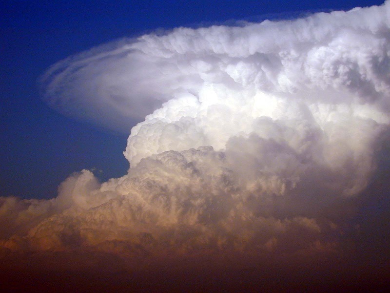
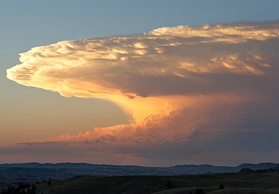
A Thunderstorm is defined as a local storm that produces lightning and thunder. Originated only by Cumulonimbus clouds, thunderstorms are usually associated with strong gusts of wind, heavy localized rain showers, and sometimes, hail. This type of storm has a relatively short life cycle, lasting less than 2 hours. However, they can build up to incredible altitudes (40,000-50000 ft.) reaching the stratosphere!
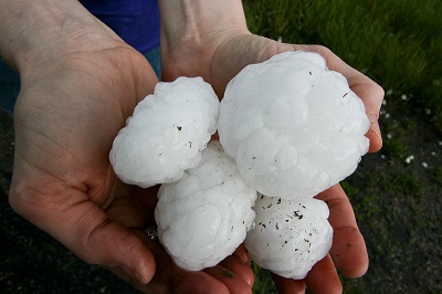
When a thunderstorm contains either: hail (1 inch or greater), winds higher than 58 mph, a tornado, or a combination of these, it is considered a Severe Thunderstorm.
Thunderstorms are more likely to occur in the afternoon and evening hours. During spring and summer months we can see a peak in the occurrence of thunderstorms in the U.S. However, this amazing weather event can happen any time of the year and can be associated to various weather systems on different scales. For example, there can be lines or clusters of thunderstorms associated to a cold front, as there are many thunderstorms in a Hurricane. In contrast, during a day with just the right conditions, you can see the development of isolated individual thunderstorms generated by daytime heating.
Watch out, be warned:
Severe Thunderstorm Watch: It is emitted when atmospheric conditions are right for a severe thunderstorm to occur in the near future. It is telling you to keep watch because there is a possibility of hazardous weather conditions and a thunderstorm warning might be issued in the near future.
Severe Thunderstorm Warning: A warning means a severe storm is heading towards your area and you need to seek shelter immediately. Strong winds, damaging hail, deadly lightning and heavy rainfall are very likely to occur over the area under a severe thunderstorm warning. It is warning you of hazardous weather conditions that are occurring (or are about to occur) over your area.
Stay safe:
Be familiar with your local emergency warning system and know the difference between all NWS alerts for severe thunderstorms. Always have a safety plan before a thunderstorm moves into your area.
During a severe thunderstorm seek shelter in a substantial building. Stay away from windows, glass and doors. Do not seek shelter on a trailer or mobile home.
If you are driving a car during a severe thunderstorm, and no shelter is available nearby, park your car away from the roadway and stay inside the vehicle with your windows closed.
If a tornado warning is issued associated to the thunderstorm, quickly move to a room with significant structural support, such as a restroom, or closet. Try to put as many walls between yourself and the outside. If safe to do so, you can also go to the lowest level (basement) of your shelter. If outdoors, seek indoor shelter immediately.
Facts:
Storm Fact: At this very instant there are approximately 2,000 thunderstorms occurring around the world!
Storm Fact: Although very dangerous, typical thunderstorms only last an average of 15-30 minutes and affect a relatively small area (an average of 15 miles).
For more information on thunderstorms, visit The National Severe Storms Laboratory.
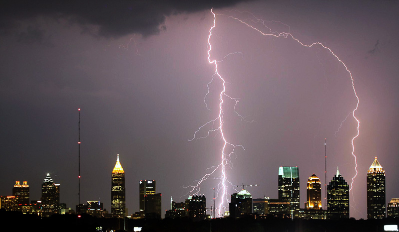
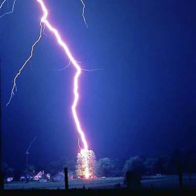
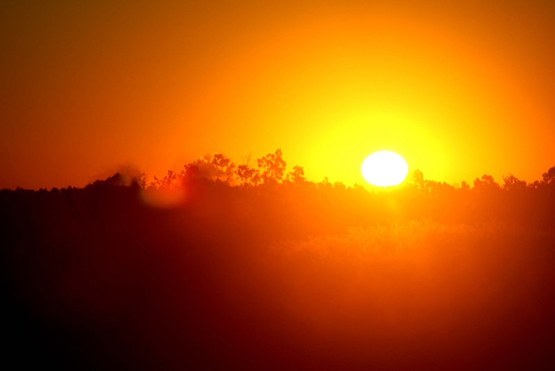
Lightning is defined as a 'transient high current discharge' (AMS Glossary). Basically, lightning is an electrical spark observed in the atmosphere - a very big one, we might add. A typical bolt releases a charge of about 1000 million to 1 billion volts, and can heat the surrounding air up to 50,000oF - that is, 5 times hotter than the surface of the sun. In fact, it is this process of fast heating of the air that causes it to expand rapidly (similar to an explosion), creating the sound wave we know as Thunder.
Lightning does not only occur from cloud to ground. In fact, many other forms of lightning have been observed: cloud-to-cloud, cloud-to-air, and intra-cloud discharges are among other commonly observed types of lightning. Lightning can often strike outside of areas of heavy rain and may occur as far as 10 miles away from any rainfall. As all electrical discharges, lightning transfers electricity between opposite charges in the atmosphere or between earth and the atmosphere. However, scientists continue to study the exact process by which the electrical charges build and distribute within a cloud, and how lightning bolts originate. One of the most accepted theories is that the presence of ice particles and different droplet sizes, and the movement of these within a cloud help to build up the electrical charge on the cloud.
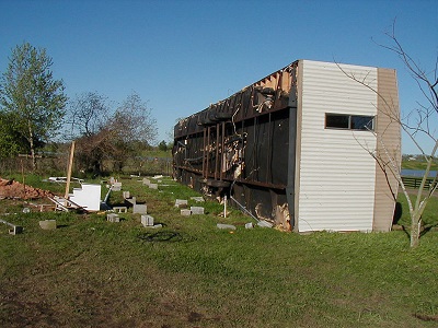
Since cloud to ground lighting occurs to neutralize electrical charge between the atmosphere and earth’s surface, it seeks for the path of least resistance to ground. Hence, lightning commonly reaches tall structures because in most cases it is the ‘easiest’ way to transfer the electrical current to ground. Therefore, we usually observe that lightning hits high buildings, towers, and trees. But this rule is not written in stone, and lightning can hit low lying objects. It all depends on where and how the charges accumulate in the surface and the cloud.
Stay Safe:
When thunderstorms are near the best place to go is inside- especially if you can hear thunder. You can take shelter on a building or a metal-topped vehicle keeping the windows up.
If no nearby shelter is available, move away from any elevated areas such as platforms or towers. Do not seek shelter under a tree or lie flat on the ground. Stay away from objects that can easily conduct electricity such as: water, fences, power lines, metal frames, etc.
Since lightning can hit areas far away from the actual thunderstorm, it is recommended that you stay inside a shelter at least 30 minutes after you hear the last sound of thunder.
Once indoors, stay away from all equipment that can put you in direct contact with electricity. Additionally, it is wise to stay away from all indoor plumbing - including sinks and faucets.
Facts:
Lightning Fact: Lightning does strike the same place twice…in fact, more than twice. It is estimated that the Empire State Building is hit on an average 23 times each year.
Lightning Fact: Rubber-soled shoes and rubber tires provide no protection from lightning. However, the steel frame of a hard-topped vehicle provides increased protection if you are not touching metal. Although you may be injured if lightning strikes your car, you are much safer inside a vehicle than outside.
For more information and facts about lightning, visit The National Severe Storm Laboratory-Lightning.
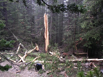
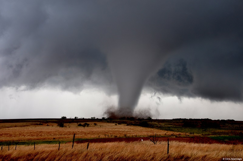
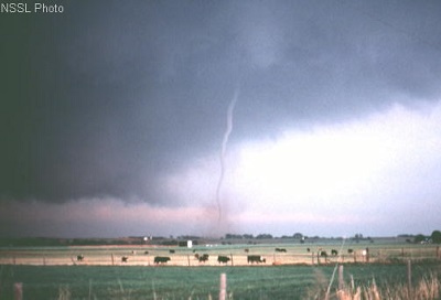
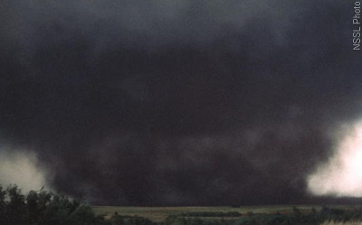
A Tornado is defined as rotating column of air that originates from the base of a thunderstorm cloud and reaches the surface. A tornado is visible only when condensation occurs creating a funnel cloud, or when dust and debris rotates with the winds. Tornadoes are the most intense atmospheric circulation with winds that can range from 67 mph up to 300 mph. However, most tornadoes are relatively small with an average diameter of less than 1.25 miles (2 km), and last about 10 minutes. Some tornadoes, however, have been observed to last more than an hour but these are rare.
Tornadoes can have many shapes and sizes. There are some known as ‘Rope Tornadoes’ because of their relatively thin appearance, while others are known as ‘Wedge Tornadoes’ given their resemblance to a thick wedge. Interestingly enough, the bigger and thicker tornadoes are not always the strongest ones. There have been very large tornadoes that only cause weak damage to structures, whereas other thin, rope like tornadoes have caused very significant damage.
The process of tornado formation is still not fully understood by atmospheric scientists and hence, there is still much ongoing research on detection and forecasting methods, and on the development of new technologies to study them. However, it has been observed that most strong and violent tornadoes are associated to severe thunderstorms known as Supercells. These are highly organized thunderstorms that exhibit rotation and are long lived (last more than an hour). However, not all supercells produce tornadoes, and tornadoes also often occur on less organized and short lived thunderstorms - hence the difficulties for forecasting exactly when and where this type of event will occur. However, meteorologists can forecast the likelihood of occurrence of tornadoes with increasing confidence due to improvements in the atmospheric modelling tools that are in use today.
The strength of a tornado is usually measured using the Enhanced Fujita Scale. The Enhanced-Fujita Scale is an update to the original Fujita Scale developed by Dr. T. Theodore Fujita (1971). The original scale was modified by a team of meteorologists and wind engineers and the enhanced scale was implemented for operational use on February 1, 2007. The new scale takes into account quality of construction and standardizes different kinds of structures.
EF0
EF1
EF2
EF3
EF4
EF5
Watch Out, Be warned:
Tornado Watch: It highlights an area where tornadoes and other severe weather are likely within the next several hours. When a watch is emitted, you should be alert and keep watch in case a tornado warning is emitted and/or you observe a tornado forming nearby.
Tornado Warning: It means that a tornado has been spotted by someone or that the radar shows the characteristic circulation associated with tornadoes in the area. When this alert is emitted you should seek shelter immediately, it is warning you that a tornado is nearby and/or moving in your direction.
The Storm Prediction Center in Oklahoma, issues the Watches, however your local NWS forecasting office is the one to issue the Warnings.
Stay Safe:
It is recommended that you have a safety plan and know where to seek shelter, before a thunderstorm is near.
Once a tornado warning is emitted for your area, seek shelter indoors immediately. Quickly move to a room with significant structural support (such as a restroom) or the lowest level (basement) of your shelter. Try to put as many walls between yourself and the outside.
Always stay away from windows and doors, during a tornado many objects can become missiles and break windows and doors.
Do not seek shelter under a bridge. It has been proven to be dangerous to seek shelter under a bridge or underpass due to reasons that include the fact that deadly debris can still fly through. Additionally, the structural integrity of the bridge may not be enough to sustain such high winds and it might collapse on top of you.
If you are outdoors and far away from any indoor shelter, and if you find it unsecure to remain in your vehicle, leave your car and go to a low spot as far away from the roads as possible. This is a last resource. If you can drive to seek shelter on a sturdy building, do it.
If the tornado is far away, try to escape. You should observe the path of the tornado relative to a stationary object for a few seconds and then start moving at right angles from its observed path of movement.
Facts:
Tornado Facts: Tornadoes have been observed on all continents, except on Antarctica.
Tornado Facts: The U.S. sees around 1,200 tornadoes a year, making it the country where tornadoes are most commonly observed – especially over the U.S. Central Plains.
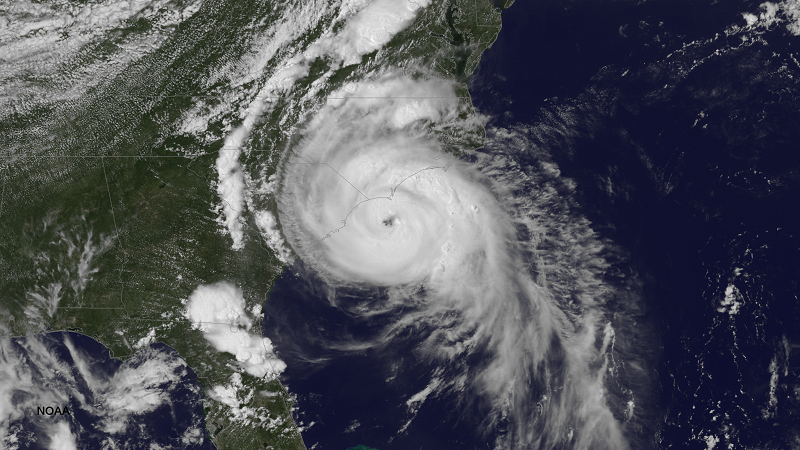
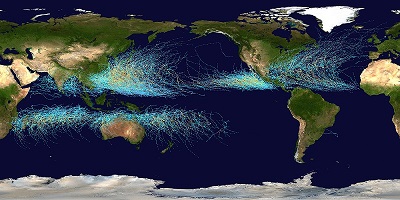
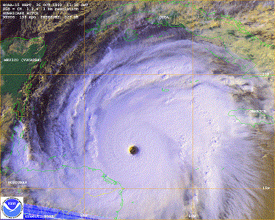
A Hurricane is an organized tropical low pressure system (not associated to an air mass front) with maximum sustained winds of 74 mph, or higher. This type of storm is known around the word by many names: Hurricanes on the Atlantic and Eastern Pacific, Typhoons on the West Pacific, and Cyclones on the Indian Ocean. In meteorology, the general term used for these events (and the preceding tropical depressions and tropical storms) is Tropical Cyclones.
Tropical Cyclones obtain their energy and moisture from the warm waters of the tropics and the characteristically moist atmosphere at these latitudes. Hence, usually hurricanes are observed to originate in waters over low latitudes above or below the Equator, but almost never at the Equator. Generally, tropical storms and hurricanes originate from the strengthening of an original atmospheric disturbance that travels from land into the ocean. Once the disturbance is over the water it continues to strengthen and organize when ocean temperatures and wind profiles in the atmosphere are just right.
Since its energy comes mostly from the ocean, once a hurricane makes landfall, it usually begins to weaken. However, hurricanes tend to move slowly – around 10 to 15 mph, and have a life cycle of about 7-10 days. It is precisely this combination of relatively slow movement, long life cycle, and big area extent what makes them the most destructive weather event on Earth.
When a hurricane forecast is issued, the forecasted hurricane tracks refer to the expected position of the center of lowest pressure, i.e. the eye of the storm. When looking at these forecasts it should be taken into account that the fields of hurricane and tropical storm force winds can extend miles away from the eye –between 50 to 200 miles.
The Atlantic Hurricane Season begins on June 1st and ends on November 30th each year. Often, Hurricanes forming in the Atlantic impact the eastern coast of the U.S. Hence it is important to be familiarized with the different strength categories and safety measures associated to Tropical Cyclones.
The strength of a hurricane is expressed using the Saffir-Simpsom scale . The Saffir-Simpson scale was developed on the early 1970’s by engineer Herbert Saffir and Dr. Robert Simpson, former director of the National Hurricane Center. This scale is based on the sustained wind speed of a hurricane and the associated potential property damage and impacts in the U.S. Note that the updated scale only estimates damage associated to wind, and does not take into account destruction associated to other hurricane hazards, such as storm surge and flooding.
Category 1
Category 2
Category 3
Category 4
Category 5
Wind speeds between 74 and 95 mph. Minimal Damage. Possible damage to building structures (primarily mobile homes), and poorly constructed signs, shrubs and trees. Loose outdoor items can become projectiles. Numerous power outages can be expected.
Wind speeds between 96 and 110 mph. Widespread Damage. Some roofing material, door, and window damage to buildings. Considerable damage to vegetation, mobile homes, and piers can be expected. A number of high rise building glass windows may dislodge and become projectiles. Widespread power outages that can last up to several days are anticipated.
Wind speeds between 111 and 129 mph. Extensive Damage. Some associated structural damage to small residences and utility buildings, with minor amount of wall failures. Mobiles homes destroyed. Uprooted or snapped trees. Power outages lasting several days or weeks are anticipated.
Wind speeds between 130 and 156 mph. Devastating damage. Some wall failures with complete house roof structure failures. Extensive damage to doors, windows and trees can be expected, as well. Electricity is anticipated to be unavailable for weeks.
Wind speeds greater than 156 mph. Catastrophic Damage. Complete roof failure on many residences and industrial buildings. Some complete building failures with small buildings blown over or away. Power outages lasting weeks or even months are anticipated.
Watch out, be warned:
Tropical storm warning: Indicates an approaching tropical storm with winds of 55 to 74 miles. It is usually issued 36 hours in advance of the expected onset/arrival of the storm. Take action to protect your house and property against tropical storm force winds. This alert warns you that tropical storm force winds are likely over your region.
Hurricane watch: Hurricane conditions are possible over the region with winds above 74 miles per hour. It is usually issued 48 hours in advance of the expected onset/arrival of tropical storm force winds. This alert means you should watch out, hurricane force winds are likely to be experienced in your region.
Hurricane warning: Indicates that hurricane conditions are expected to impact the region. Winds above 74 miles per hour are expected. It is usually issued 36 hours in advance of the onset/arrival of tropical storm force winds. This alert is warning you that hurricane force winds will be experienced over your region.
Safety:
Before a tropical cyclone develops, prepare a plan and make sure you and your relatives know what to do when a hurricane or tropical storm warning is issued for your region.
When a tropical storm or hurricane watch is issued, is time to protect your home by covering windows and securing loose items around your home. As a warning is issued, use time wisely to finish up all preparations and move into (or evacuate to) a secure place before the hurricane arrives.
During the passage of a hurricane, remain indoors in a small interior room, closet, or hallway on the lowest level of the structure throughout the duration of the storm. Put as many walls as you can between you and the outside. It is not wise to be exposed outdoors due to the many objects that become projectiles under tropical storm and hurricane force winds.
Stay away from windows, skylights and glass doors.
If you know the eye of the storm will be moving over your area, be prepared for a short period of calm. DO NOT go outside! Hurricane force winds will be returning shortly as the opposite wall of the hurricane moves through.
Always follow the directions of local officials if an evacuation is required.
Facts:
Hurricane fact: Hurricanes are considered the most destructive weather event in the world, even though tornadoes might reach higher wind speeds. This is due to the extensive amount of area a hurricane can cover which combined with its duration, adds up to more destruction than a single tornado.
Hurricane fact: Hurricanes are rarely observed on the east coast of South America. This is due to the lack of weather disturbances moving off the Southern tip of Africa onto the Ocean that could then strengthen to become a tropical cyclone.
For more information concerning watches and warnings, go to the National Hurricane Centerpage

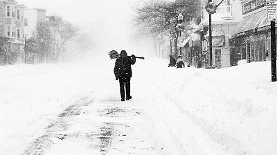
A Winter Weather event is defined by the NWS as ‘a winter weather phenomenon that impacts public safety, transportation, and/or commerce’. During and extreme cold or winter weather event, the main types of precipitation are solid at the ground: snow, sleet, and freezing rain. Sleet is rain that turns into ice pellets before reaching the ground. In turn, freezing rain is liquid precipitation that freezes when it comes in contact with the ground. Usually, significant winter weather events occur during the winter season, i.e. from Mid-October through Mid-April.
There are 4 types of winter storms: Blizzards, Ice Storms, Lake Effect Storms and Snow Squalls. Each type poses different risks and damages to life and property, however most deaths on a winter storm are only indirectly related to the storm itself. Most deaths are associated to accidents on the road, hypothermia, and heart attacks while shoveling snow.
Although we might not get much snow here, it is important to be familiarized with the meaning of the various alerts that the National Weather Service provides during a winter weather event.
Watch out, be warned:
Winter Weather Advisory: It means that cold, snow, freezing rain and/or sleet accumulations are expected over the region in the near future.
Winter Storm Watch: Indicates that severe winter weather such as heavy snow or ice is possible within the next day or two. It is generally issued within 12-48 hour in advance of the severe winter event expected. This alert is suggests to watch out for further development or weather details, since hazardous conditions are possible and warning might be issued at a later time.
Winter Storm Warning: Indicates that severe winter conditions have begun or are imminent. A warning is usually issued within 12-24 hours before the event is expected to begin. It is warning you that hazardous winter conditions will impact or are already impacting your region.
Blizzard Warning: Issued when heavy snow and strong winds are expected to produce near zero visibility, deep drifts and wind chill. When a blizzard warning is issued, immediately seek shelter indoors and remain there until weather conditions improve. This alert warns you that life threatening conditions associated to the severe winter weather event are occurring over your area.
Frost/Freeze Warning: Issued when below freezing temperatures are expected in the region and any liquid precipitation, or dew is likely to freeze over the surface.
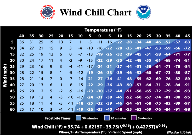
Wind Chill Advisory: Issued when the amount of cooling of the human body due to air motion, i.e. wind chill, can cause inconveniencies without meeting the local wind chill warning criteria. It is usually accompanied by advice and safety measures given the expected conditions.
Wind Chill Warning: Indicates wind chill temperatures are expected to pose a hazard to life if exposure occurs over several minutes. Seek indoor shelter immediately, and remain there until weather conditions have improved. This alert warns you of life threatening conditions that are being (or will be) observed over your region.
Stay Safe:
During a winter weather event, dress appropriately for the cold weather. Wear layers to keep warm as the temperature drops. A warm hat, 2-3 layers of shirts and jeans, gloves and warm water proof boots are recommended for cold weather. On extremely cold weather, wear 3 or more layers and use a face mask, if you need to be out.
Reduce the amount of time you travel by car as conditions deteriorate. Always pack an emergency kit on your car and make sure to prepare your vehicle for winter conditions before the onset of winter weather.
For more information about our local Wind Chill values and protective controls, visit our web page’s Wind Chill section.
Facts:
Snowfall or big accumulations of snow are not needed to have blizzard conditions. If measured wind speeds are higher than 35 mph and visibility values of less than ¼ of a mile are observed for more than 3 hours, then you have blizzard conditions.
What is commonly known as a Thundersnow is nothing more than a thunderstorm with snowfall instead of rainfall. Both types of storms are characterized with strong upward air motions within the storm cloud.
Extreme Heat usually is associated to temperatures that hover 10 degrees or more above the average high temperature for the region and last for several weeks. Extreme heat associated to heat waves is one of the main causes of weather related fatalities due to the fact that most people undermine the dangers associated with these common and widespread events (NWS).
Heat waves often cover large geographical areas, hence impacting many people at once. When heat and humidity are combined, the temperature felt by the human body differs from that measured on a thermometer. The body’s ability to cool down is impacted due to how fast the body is heating up and hence, many health dangers are associated to extreme heat events.
Some of the dangers of extreme heat exposure are: Dehydration, heat related illness, which can lead to death if not treated. Here in SRS we have implemented our very own Heat Stress Index meeting the specific needs of workers on the site. We encourage employees to be familiarized with the pertaining protective and safety measures associated to extreme heat events.

Stay Safe:
Before Exposure- Stay indoors and avoid extreme temperature changes.
- If air conditioning is not available, stay on the lowest floor out of the sunshine.
- Keep electric fans running.
- Drink fluids often, particularly water or juice. Drink even if you do not feel thirsty, this helps your body's thermostat to stay cool. Avoid alcoholic beverages (including beer), which dehydrate the body.
- Eat small, frequent meals. Avoid foods that are high in protein, which increase metabolic heat.
- Keep pets indoors and refill their water bowls frequently.
- If you must go out, wear lightweight, light-colored clothing to reflect sun light.
- Avoid strenuous outdoor activity. If you must engage in strenuous activity, do it during the coolest part of the day, between 4 am and 7 am.
- Cover all exposed skin with a high SPF sun screen, and wear a wide brimmed hat to protect your face and head.
- Drink plenty of fluids.
- Continue drinking plenty of water and juice.
- Never take a cool shower immediately after becoming overheated. You may cool too quickly and become ill, nauseous, or dizzy.
Watch out, be warned:
The Atmospheric Technologies Group provides daily Heat Stress values, when applicable. Additionally, our webpage offers a list of protective and safety measures according to the stress level. We encourage all SRS employees, especially workers who will spend time outdoors, to be alert for the daily values of Heat Stress and to practice the according safety measures described on our site.
Facts:
Heat Fact: Even days with temperatures as low as the 70’s can exhibit low categories of Heat Stress in some areas - especially inside cars and enclosed areas with no ventilation and direct sunlight.
Heat Fact: Urban areas are usually slightly warmer than rural areas, hence, usually higher death rates were observed for cities than for areas outside of the city. This has improved with the widespread use of air conditioning; however there are still a significant number of fatalities associated to extreme heat conditions.
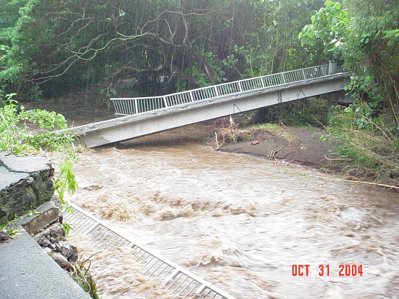
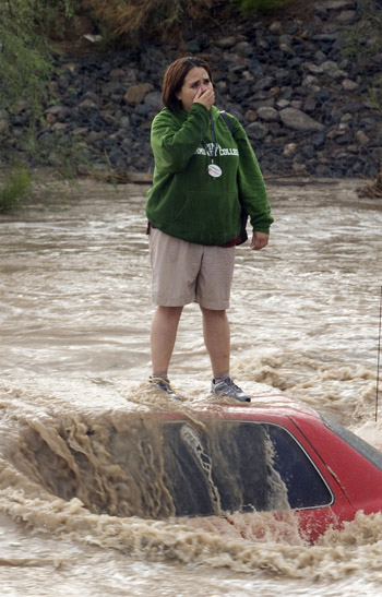
Flooding is defined as an overflow of water onto land areas that are normally dry. A flood can be originated by heavy rains, ocean waves over the coast, fast snow melting, and when levees or dams break (NOAA NSSL). A Flash Flood occurs when there is a rapid rise of water level in streams, creeks, rivers, or other waterways, or in urban areas, usually observed as a result of intense rainfall (AMS Glossary). Flash Floods can also occur with moderate rainfall that occurs over saturated land surfaces. This type of flood is considered the most dangerous due to its speed and relative unpredictability- they can happen with little or no warning.
Generally, the key element in the initiation of flash floods is an event of heavy or intense rainfall that occurs in a relatively short period of time (less than 6 hours). The starting time of a flash flood depends on many factors, including the characteristics of the impacted watershed, type of soil, and the amount of soil saturation over the area of rainfall. Hence, a flash flood can start within minutes or hours of the particular rain event, and it can also occur away from the rain event in question. This is the reason why flash floods can be so dangerous and often have little warning.
Flooding causes more deaths and property damage than any other severe weather event in the United States! Part of the cause of fatalities is the underestimation of the speed and strength of water in a flash flood event. Only 6 inches of moving water in a flood can sweep vehicles off the roadway (NWS). Sadly, many people ignore this and still attempt to drive through flooded roads. Although flash floods are relatively uncommon here, it is important to become familiar with the safety tips and measures during a flash flood event.
Watch out, be warned:
Flash Flood Advisory: Issued when flooding is not expected to be significant enough to issue a flash flood warning but is expected to still pose a risk to life and property.
Flash Flood Watch: Indicates that conditions are favorable for flooding, and that flooding is possible in the near future. Be prepared to take protective actions if a warning is issued.
Flash Flood Warning: Indicates that hazardous weather conditions that can cause flooding have been observed. In other words, a flash flood is imminent or is already occurring in the area. If you are on a flood prone area, move immediately to high ground even if your area is not receiving significant rainfall.
Safety:
One of the most important safety measures is NOT driving through flooded roads or walking through significantly flooded areas.
Stay alert to all public information given by local authorities.
Avoid flood waters and flooded areas at all cost and evacuate your location if you notice that water starts to rise. When evacuating from flooding areas, always move to higher ground.
Do not go into any room where water has covered the electrical outlets or if electrical cords are submerged. There might be electricity on the water.
Facts:
Flood Fact: A flash flood can take minutes or hours to develop. The time of onset depends on local watershed and soil characteristics of each region.
Flood fact: A flash flood is not only associated to severe weather and excessive rainfall. A flash flood warning can be issued associated to a dam failure or broken levee.